Weather Front Diagrams
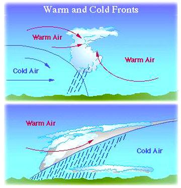
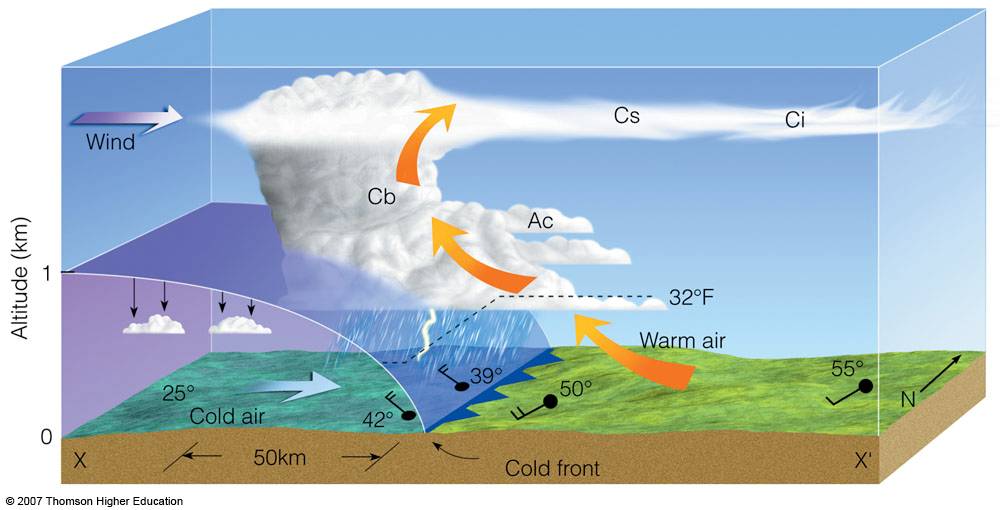
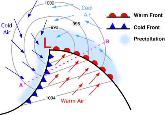
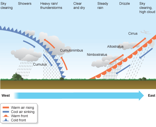
A cold front is defined as the leading edge of a cooler mass of air, replacing (at ground level) a warmer mass of air, which lies within a fairly sharp surface trough of low pressure. It forms in the wake of an cyclone. at the leading edge of its cold air advection pattern, which is also known as the cyclone's dry conveyor belt circulation. Temperature changes across the boundary can exceed 30 °C (54 °F). When enough moisture is present, rain can occur along the boundary. If there is significant instability along the boundary, a narrow line of thunderstorms can form along the frontal zone. If instability is less, a broad shield of rain can move in behind the front, which increases the temperature difference across the boundary. Cold fronts are stronger in the fall and spring transition seasons and weakest during the summer.
A warm front is a warm air mass, and is typically located on the equator. Warm fronts lie within broader troughs of low pressure than cold fronts, and move more slowly than the cold fronts which usually follow because cold air is denser and less easy to remove from the Earth's surface. This also forces temperature differences across warm fronts to be broader in scale. Clouds ahead of the warm front are mostly rainfall gradually increases as the front approaches. Fog can also occur preceding a warm frontal passage. If the warm air mass is unstable, thunderstorms may be embedded among the stratiform clouds ahead of the front, and after thundershowers may continue.
A stationary front is a boundary between two different air masses, neither of which is strong enough to replace the other. On a weather map, this is shown by an inter-playing series of blue spikes pointing one direction and red domes pointing the other. They tend to remain essentially in the same area for extended periods of time, and waves sometimes move along the front boundary. A wide variety of weather can be found along a stationary front, but usually clouds, precipitation, and thunderstorms are found there. Stationary fronts will devolve into shear lines, but can change into a warm or cold front if conditions aloft change. The temperature of the ocean surface is usually the same on both sides of the frontal boundary and modifies the air masses on either side of it to correspond to its own temperature. Stationary fronts always stay still.
An occluded front is formed when a cold front overtakes a warm front. When this occurs, the warm air is separated (occluded) from the cyclone center at the earth's surface. The point where the warm front and the occluded front meet (and consequently the nearest location of warm air to the center of the cyclone) is called the triple point.